


SEVERE TROPICAL Storm Bualoi, locally known as Opong, could intensify into a typhoon before making landfall in the Bicol Region on Friday, according to the state weather bureau.
“Opong will continue to intensify while over the Philippine Sea and may reach typhoon category before making landfall over Bicol Region,” the Philippine Atmospheric, Geophysical and Astronomical Services Administration’s (PAGASA) said in its 5 p.m. bulletin, published on its website.
“It will then weaken as it crosses the archipelago, although it will likely remain as a typhoon or severe tropical storm during the passage. Re-intensification is highly likely once Opong emerges over the West Philippine Sea.”
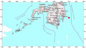
The center of Opong, which intensified into a severe tropical storm, was estimated at 670 kilometers east of Surigao City, Surigao del Norte. It has maximum sustained winds of 95 km per hour (kph) near the center, and gustiness of up to 115 kph.
“Opong is forecast to begin moving west northwestward while approaching Eastern Visayas — Southern Luzon area,” PAGASA said, noting it may make landfall over Bicol region on Friday morning or afternoon and cross southern Luzon throughout Friday.
“Afterwards, it will continue moving generally west northwestward over the West Philippine Sea and exit the Philippine Area of Responsibility on Saturday (Sept. 27).”
The state weather bureau has so far raised a Tropical Cyclone Wind Signal (TCWS) No. 1 over Catanduanes, Camarines Sur, Albay, Sorsogon, Masbate, Samar, the rest of eastern Samar, Biliran, and the northern portion of Leyte.
Northern Samar, and the northern portion of Eastern Samar is now under TCWS No. 2.
PAGASA weather specialist Benison Jay N. Estareja said at an 11 a.m. briefing that as the cyclone further approaches and intensifies, the warning signal may be raised up to No. 4.
Meanwhile, more than 692,000 individuals, or over 156,000 families, were reported affected by recent tropical cyclones Ragasa (locally named Nando) and Mitag (locally named Mirasol), along with the effects of the southwest monsoon, according to the National Disaster Risk Reduction and Management Council (NDRRMC) latest advisory.
The mainly affected areas are Bicol Region, Cagayan Valley, and central Luzon, as well as the Bangsamoro Autonomous Region in Muslim Mindanao, which recorded the highest number of affected individuals at more than 486,000.
The NDRRMC also reported that the estimated damage to agriculture has reached P14.8 million. It added that it has already provided nearly P11 million worth of assistance to the affected families. — Edg Adrian A. Eva