


TROPICAL STORM Nokaen, locally known as Ada, is expected to track farther away from land while maintaining its strength over the next 24 hours, though the state weather bureau warned that strong winds, rain and rough seas would continue to affect large swaths of eastern Philippines as the northeast monsoon intensifies.
Ada was last seen on Sunday about 140 kilometers (km) northeast of Virac, Catanduanes, slowly moving east-northeast with maximum sustained winds of 75 kilometers per hour, according to the Philippine Atmospheric, Geophysical and Astronomical Services Administration (PAGASA).
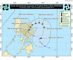
The storm was forecast to continue moving northeastward through Monday before shifting into a looping track over the Philippine Sea east of Luzon, it added.
It said Ada was likely to remain a tropical storm as it stays offshore before weakening into a tropical depression by Tuesday and further slowing into a low-pressure area by Thursday as monsoon winds strengthen.
An earlier weakening remains possible, it added, while cautioning that heavy rain and strong winds could still occur outside the forecast track and confidence cone.
Wind Signal No. 2 was expected to stay in place over Catanduanes and parts of Camarines Sur, with Signal No. 1 covering portions of southern Quezon, the Bicol Region and Northern Samar, posing minimal to moderate risks to life and property.
Beyond the storm’s immediate circulation, enhanced monsoon winds were forecast to bring strong to gale-force gusts to northern and eastern Luzon, Bicol and parts of Eastern Visayas through Tuesday.
Coastal flooding remained a concern in low-lying communities in Camarines Sur, Catanduanes, Albay and Sorsogon, where storm surge of up to two meters was possible within the next 24 hours.
At sea, rough to moderate conditions were forecast to persist along the eastern seaboards of Luzon and parts of the Visayas, prompting warnings for small vessels to avoid sailing as authorities brace for lingering weather disruptions even as the storm gradually weakens.
The storm’s forecast positions showed a continued drift away from land: by 8 p.m. on Sunday, Ada was expected to be 425 km east of Infanta, Quezon; by 8 a.m. on Monday, 500 km east of Baler, Aurora; and by 8 p.m. on Monday, 565 km east of Casiguran, Aurora.
On Tuesday, it was projected to be 705 km east of Casiguran in the morning and 830 km east of Central Luzon by evening.
By Wednesday morning, Ada was expected to be 810 km east of Southeastern Luzon and then 390 km east of Guiuan, Eastern Samar by Thursday.
Meanwhile, Ada had already triggered flooding, landslides and transport disruptions, according to an 8 a.m. situation report from the National Disaster Risk Reduction and Management Council.
More than 10,000 people had been affected, with evacuations underway in several regions. It was earlier reported that two died in Region 5.
Authorities reported flooded communities in Bicol and Caraga, damaged roads and bridges, power interruptions and the suspension of sea travel in dozens of ports, leaving thousands of passengers and cargoes stranded. — Chloe Mari A. Hufana